The soil ecosystem is a biodiverse, complex natural habitat upon which our survival depends.
Preservation of the natural soil properties becomes increasingly important to secure food production and other biological resources. As soil may not be artificially reproduced, sustainable use is required to preserve soil as a resource.
An ecological soil report records the natural soil functions, as well as damage done to soil. Some adverse soil conditions may not be caused by chemical substances, but rather result from soil changes such as compaction, erosion, loss of organic matter or decline in biological activity. Such changes can cause considerable soil damage with significant financial consequences.
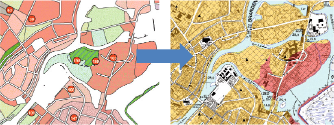 „Delineation of areas with elevated contamination levels using GIS“ a project in cooperation with ARC-GREENLAB GmbH To the left: sampling points; to the right: map showing interpolated contamination levels
What can we provide?
Our long-term experience coupled with a solid soil science background allows for qualified soil investigation and assessment of properties, sensitivities or damage as well as potential for future use/s.
- Soil mapping according to the “soil mapping manual”, base analysis to determine the natural soil functions and soil types as well as adverse soil conditions
- collection of undisturbed soil samples for analysis of physical properties, and collection of single and composite soil samples for soil chemical analyses
- Investigation and evaluation of
- nutrients, organic matter, pH and other parameters to determine the yield potential for gardeners and farmers
- elevated contamination levels and mapping of these Areas (Meyer, U. & M. Kraussmann 2006, pdf)
- humus quality to assess biological activity and soil structure
- the risk of erosion of agricultural soils to prevent soil loss by wind and water
- of soil material used as fill layer according to the requirements of the German Soil Protection Act and Ordinance (§ 12 BBodSchV) to establish a rooting zone
- of soil properties such as moisture, waterlogging conditions , salinity, high nitrate levels, poor nutrient supply, acid or basic soil properties, soil compaction, or heavy metal contents using plant bioindicators (UBA-Texte 36/00 pdf)
- of the potential to unseal sealed surfaces in the context of changing land use to increase rainwater infiltration (in cooperation with the company ARC-GREENLAB GMBH we developed a regional GIS tool showing the unsealing potential of potentially suitable areas)
- of soil compaction using a penetrometer to determine the effective rooting depth of plants
- of waterlogging at sport fields and green areas


